
Bushfire Airborne Intelligence, Surveillance & Reconnaissance
Air Affairs Australia (AAA) provides Airborne Bushfire
Reconnaissance flight operations utilising customised Infrared
Line-scan imaging systems combined with purpose modified aircraft.
With over 25 years of bushfire scanning operations throughout
Australia, AAA currently boasts a globally unmatched capability in
this unique field of airborne special missions.
The Infrared Line-Scanner systems at the heart of the service have
been developed specifically for bushfire intelligence data,
providing high quality and accurate imagery. The combination of
sensors utilised on the linescanners are optimised for maximum
sensitivity and definition over active bushfires, providing detail
in fire front locations and intensity, combined with accurate
post-burn definition.
Dedicated fire mapping / detection flight operations are conducted
during both day and night-time hours, with fire imaging unaffected
by smoke cover. Image and ancillary data are rapidly delivered from
the aircraft via Satellite and made available to relevant State Fire
Authorities in near real-time. The use of high-speed Learjet
aircraft provides high efficiencies in large area coverage and
long-distance transit. Also, two AAA Beechcraft Kingair 200 aircraft
are modified for the line-scanner system installation, providing
additional capacity and flexibility in aircraft platforms available.
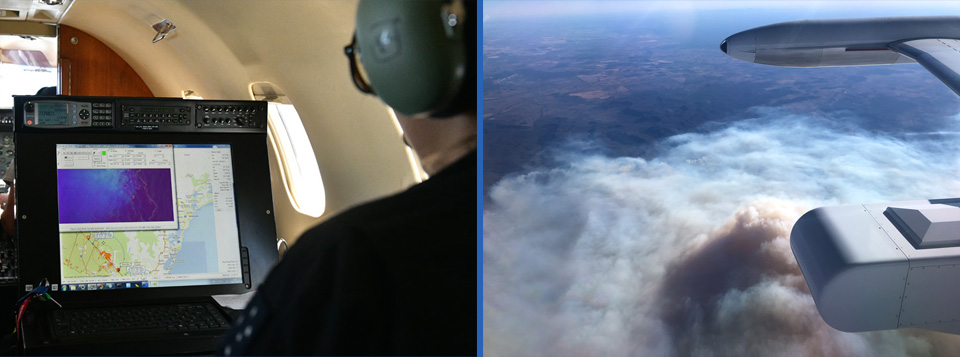
One of our specialist Aircrew during a firescan operation & our firescan pod fitted on the wing of a learjet aircraft over fire activity
The Airpod-101 (wing-mounted pod system) designed and manufactured
by AAA, permits rapid changeover between aircraft in the event of
either unscheduled or scheduled maintenance.
All aspects of the fire scanning operation, from scanner hardware
and software system design, flight planning systems, ground
operations support systems and flight execution systems, have been
designed and developed in-house. Combined with complete aircraft
maintenance engineering, AAA has evolved with a priority focus on
total independence as a provider of special mission aircraft
operations and support services.
The current capability today consists of:
- 5 customised Multispectral / Infrared Line Scanner systems.
- Purpose modified Kingair 200T aircraft.
- Custom designed and manufactured AIRPOD-101 Wing Pod system for Learjet Line Scanner operations.
- Rapid on-board image data processing system.
- Broadband Satellite Communication system enabling rapid world-wide data transfer.
Images from the system
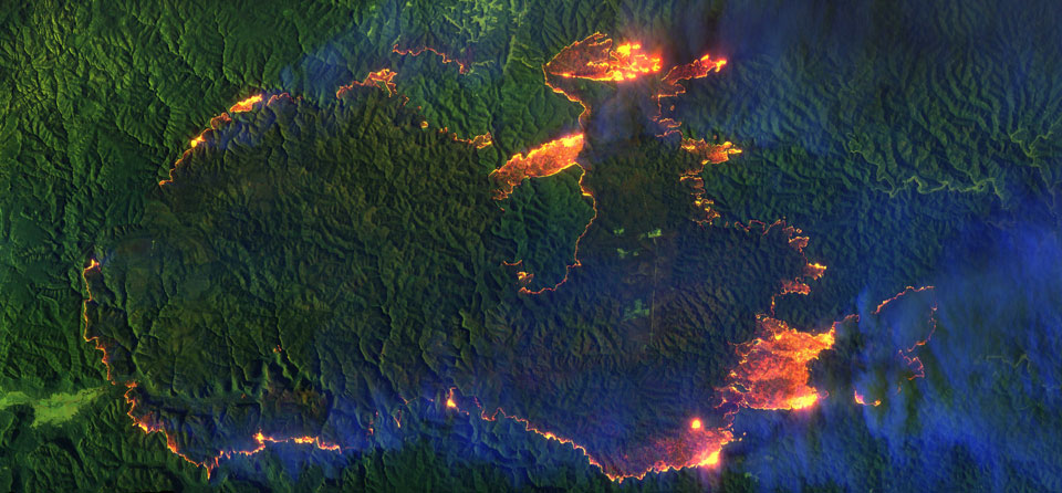
The Gospers Mountain fire in the Wollemi National Park, NSW, on the afternoon of November 15th, 2019. At the time of capture, the fire had grown to around 1,100 sq km (110,000 Hectares). The Learjet acquiring this imagery executed two high level passes (27,000ft) to efficiently cover the required terrain.
Ignited by a single lightning strike on October 26th, 2019, the Gospers Mountain fire grew to be the largest single ignition point bushfire in Australian history. Linking with numerous other going bushfires, the created ‘Megafire’ consumed over 512,000 hectares of forest and grasslands. On February 10th, 2020, the NSW Rural Fire Service announced a torrential rain event the preceding week had finally extinguished the Gospers Mountain Megafire.
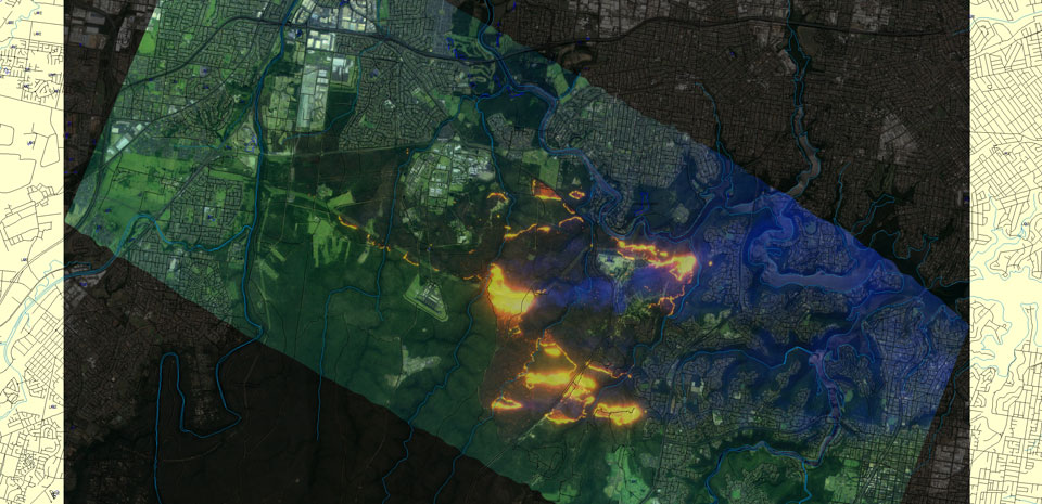
In April 2018, a bushfire threatened homes in Sydney’s South West. Due to unseasonably warm weather and strong winds, the Moorebank fire (described as ‘ferocious’ by the NSW Rural Fire Service), grew rapidly burning through the Holsworthy Army base training grounds, then east towards the fringe suburban areas of Menai.
Continuous imaging of the active fire was provided by multiple Air Affairs Firescan aircraft. The sustained ‘aircraft on top’ of the situation continued supplying critical intelligence well into the night, as unabated strong winds maintained the threat to residential properties. Through dense smoke, the imagery provided accurate fire front positions and forward fire spotting, immediately made available via satellite and used in the RFS GIS/Mapping systems.
With a pre-dawn easing of wind conditions, the 500 firefighters and 15 aircraft attacking the blaze successfully avoided any residential property losses.